State House Districts
Pennsylvania is divided into 203 House districts, each represented by one member elected every two years.
New boundaries for House districts based on the 2010 US Census went into effect in January 2015. Below are the maps for the 26 House districts that include Philadelphia, as well as a link to the maps for the rest of the state.
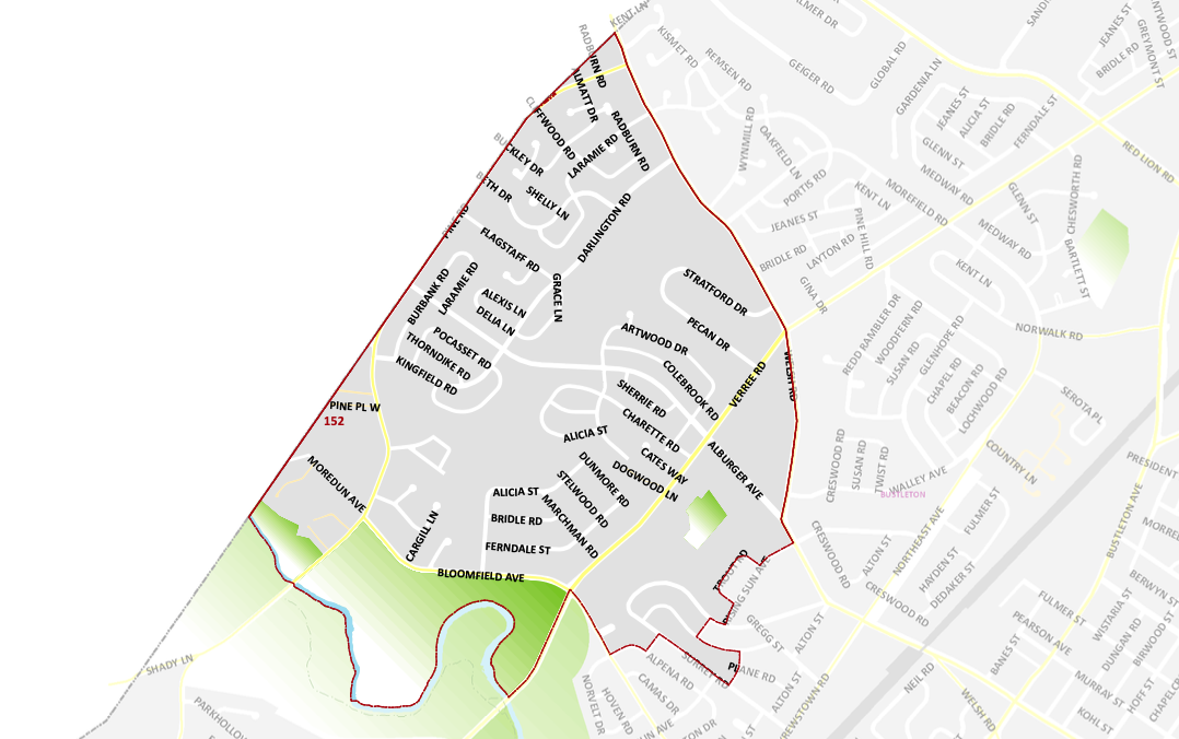
District 152 Map
Pennsylvania’s 152nd House district is mostly in Montgomery County but also includes parts of Fox Chase in Philadelphia.
Wards and Divisions in District 152: Ward 63*(Divisions 16-21 and 24) (This district also includes parts of Montgomery County.)
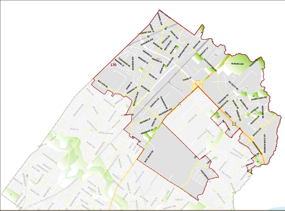
District 170 Map
Pennsylvania’s 170th District includes all of Somerton, Chalfont, Millbrook, Parkwood, and parts of Bustleton.
Wards and Divisions in District 170: Wards 58*(Divisions 01-08, 12, 14, 15, 18, 20-25, 27, and 29-44), 66*(Divisions 01, 03, 04-06, 08-10, 12-16, 18, 20, 22, 23, 31, 33, 34, and 38-41.)
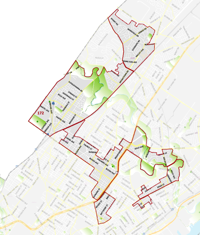
District 172 Map
Pennsylvania’s 172nd District includes parts of Montgomery County consisting of the borough of Rockledge and Part of Philadelphia County consisting of Bustleton, Fox Chase and Rhawnhurst.
Wards and Divisions in District 172: Wards 41*(Divisions 19, 23, and 24), 54*(Divisions 10, 14, 15, and 19-22), 55*(Divisions 09, 10, and 13-17), 56*(Divisions 01, 03, 04, 08, 09, 13-15, 32-34, and 40), 57*(Divisions 13 and 14), 58*(Divisions 09, 10, 13, 16, 17, 19, and 26), 63*(Divisions 01-15, 22, 23, and 25), and 64*(Divisions 01, 03, 05, 07-09, 15) (This district also includes parts of Montgomery County.)
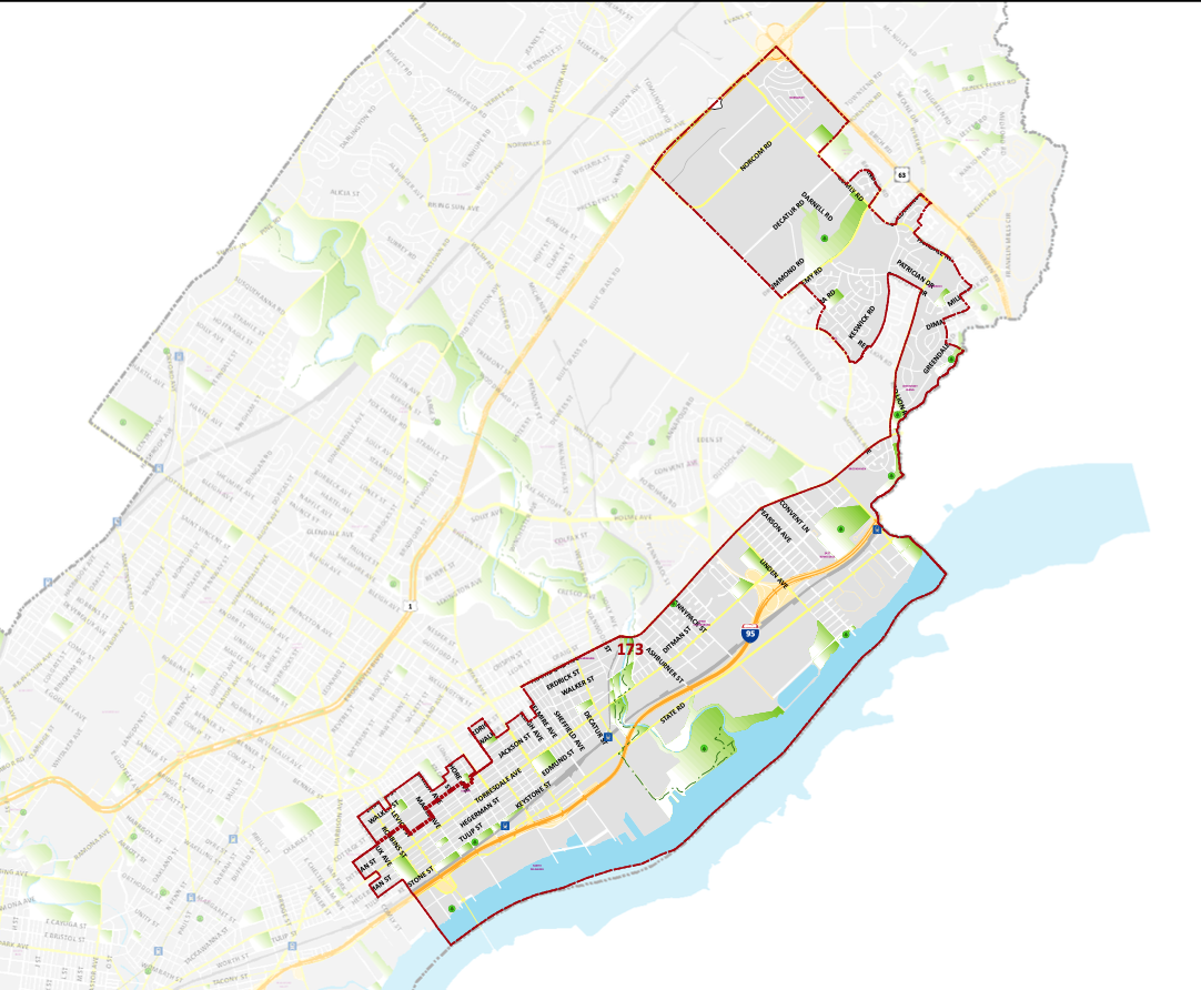
District 173 Map
Pennsylvvania’s 173rd District includes all of Homesburg, East Torresdale , and parts of Tacony, Mayfair, Upper Homesburg, Torresdale, morrel Park, Brookhaven, Parkwood, Chalfont, and Normandy.
Wards and Divisions in District 173: Wards 41*(Divisions 04, 06, 08-18, 20-22, 25, and 26), 55*(Divisions 04, 05, 07, 26, and 28), 65, and 66*(Divisions 02, 07, 11, 17, 24, 29, 30, 32, 35-37, and 42-45.)
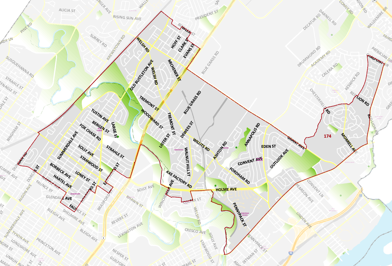
District 174 Map
Pennsylvania’s 174th District includes Rhawnhurst, and parts of Northeast Philadelphia
Wards and Divisions in District 174: Wards 56*(Divisions 02, 05, 06, 10-12, 16-31, 35-39, and 41), 57*(Divisions 01-12, and 15-28), 58*(Divisions 11 and 28), and 66*(Divisions 19, 21, 25-28, and 46.)
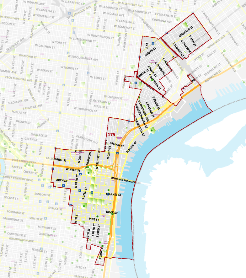
District 175 Map
Pennsylvania’s 175th District includes Old City, parts of Washington Square West, Northern Liberties, Fishtown and Kensington.
Wards and Divisions in District 175: Wards 02*(Divisions 01, 15, 16, and 25-27), 5*(Divisions 01-05, 10, 12, 13, 16-19, 21, 24-27), 18*(Divisions 02, 04-07, 10-12, and 17), 25*(Divisions 09, 13-21, and 24), and 31*(Divisions 01-05, and 07-14.)
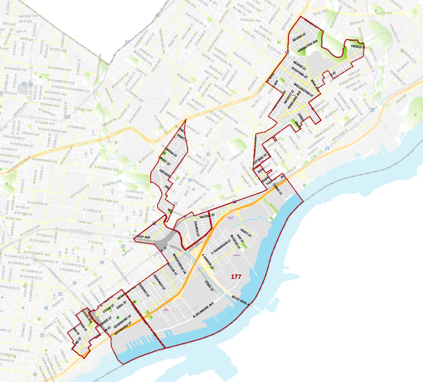
District 177 Map
Pennsylvania’s 177th District includes Bridesburg, Northwood Mayfair and parts of Port Richmond, Fishtown, Lawncrest and Tacony.
Wards and Divisions in District 177: Wards 23* (Divisions 01, 03, 04, 08, 09, 13, and 14), 25*(Divisions 01-08, 10-12, 22, and 23), 31*(Divisions 06, and 15-19), 41*(Divisions 05 and 07), 45*(Divisions 01-07, 12, 15, 18, 20, 22-25), 55*(Divisions 01-03, 06, 08, 11, 12, 18-25, 27, and 29), and 64*(Divisions 02, 04, 06, 10-14, and 16-18.)
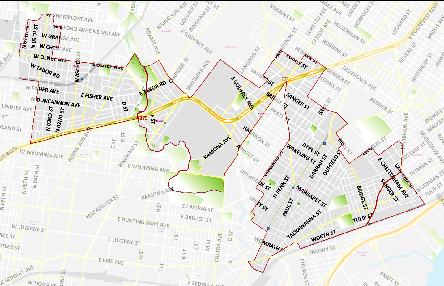
District 179 Map
Pennsylvania’s 179th District includes parts of Frankfords, Olney, Oxford Circle, Wissinoming and Feltonville.
Wards and Divisions in District 179: Wards 23* (Divisions 02, 05-07, 10-12, and 15-23), 35*(Divisions 15, 23, 24, 26, 29, and 30), 41*(Divisions 01-03), 42*(Divisions 12-21, 24, and 25), 53*(Division 01), 54*(Division 01), 61*(Division 01-03 and 07), and 62*(Divisions 01-12, 14, and 19.)
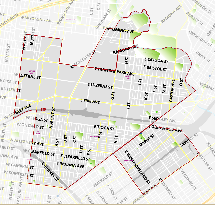
District 180 Map
Pennsylvania’s 180th District covers a majority of West Kensington, including parts of Juniata Park, Fairhill, Harrowgate, and Tioga Park.
Wards and Divisions in District 180: Wards 07, 33, 42*(Divisions 01 and 23), and 45*(Divisions 08-11, 13, 14, 16, 17, 19, and 21.)
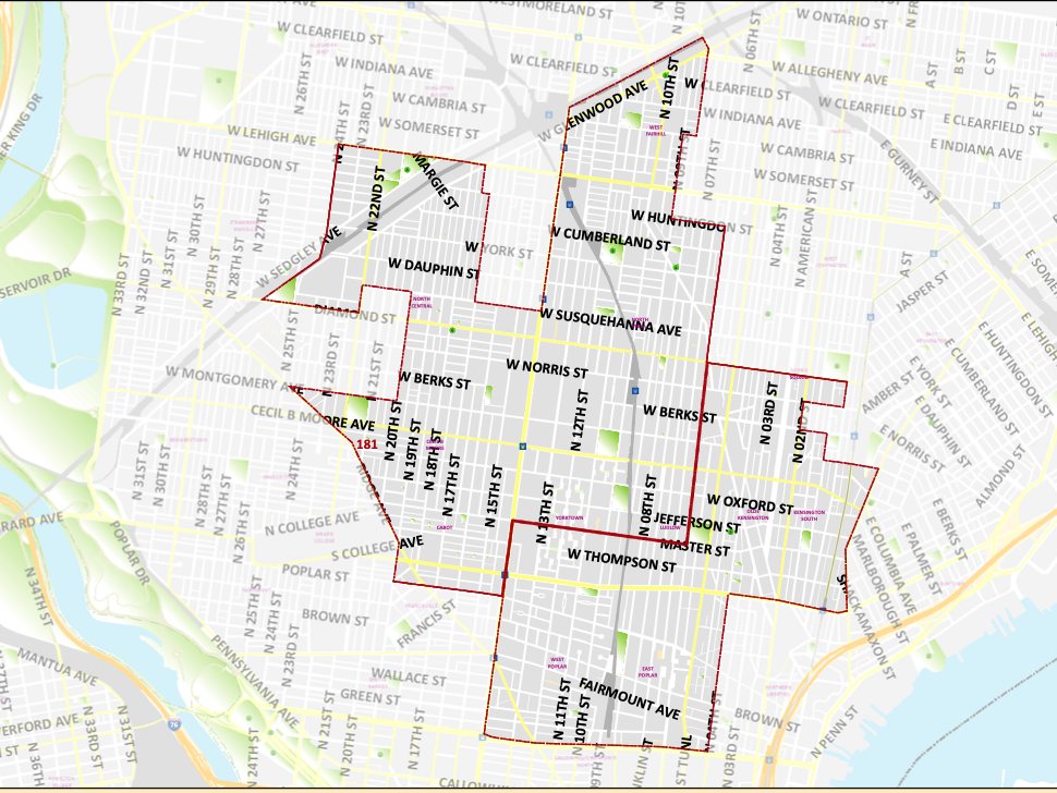
District 181 Map
Pennsylvania’s 181st District includes parts of North and North Central Philadelphia, West Poplar, Glenwood, Francisille, Northern Liberties, Hunting Park, Feltonville and Kensington.
Wards and Divisions in District 181: Wards 05*(Divisions 15, 20 and 23), 14, 16*(Divisions 06-18), 18*(Divisions 01, 03, 08, 09, 13-16), 20, 32*(Divisions 05-09, 11, and 12), 37*(Divisions 01-14, 17, and 21), and 47.
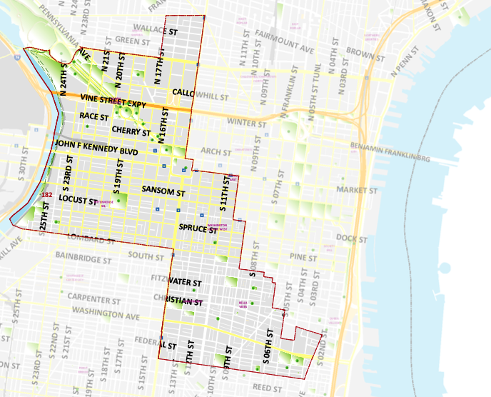
District 182 Map
Pennsylvania’s 182nd District includes part of Rittenhouse, Fitler Square, Logan Square, Midtown/Gayborhood, Washington Square West, Bella Vista, Hawthorne, Fairmount, Queen Village, and Market East and small parts of East Passyunk
Wards and Divisions in District 182: Wards 02*(Divisions 02-14 and 17-24), 05*(Divisions 06-09, 11, 14, 22, 28, and 29), and 08.
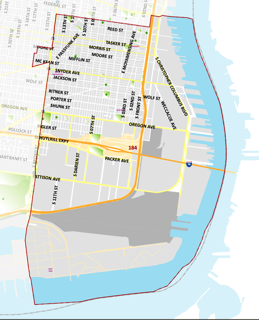
District 184 Map
Pennsylvania’s 184th District includes lower Pennsport, East Passyhunk Crossing, Dickinson Narrows, Lower Moyamensing, Whitman and parts of South Philadelphia.
Wards and Divisions in District 184: Wards 01, 39, 48*(Divisions 14 and 20.)
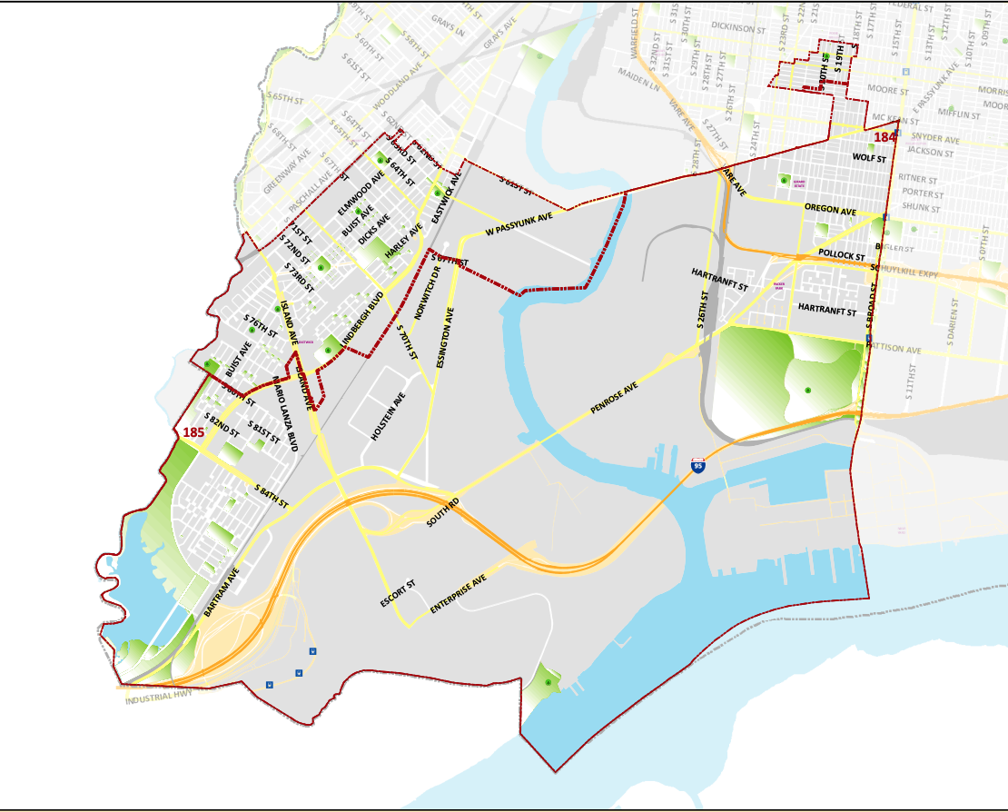
District 185 Map
Pennsylvania’s 185th District includes part of Delaware County consisting of the township of Darby and boroughs of Colwyn and Sharon Hill and part of Philadelphia County.
Wards and Divisions in District 185: Wards 26, 36*(Divisions 10-13, and 15), 40* (Divisions 01, 15-18, 22, 27-32, 35-46, and 48-51), and 48*(Divisions 01-03, and 13) (This district also includes parts of Delaware County.)
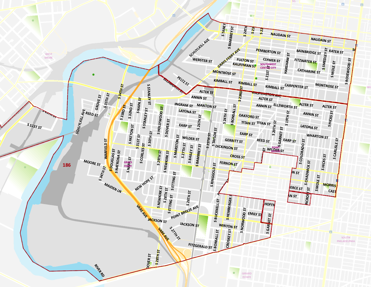
District 186 Map
Pennsylvania’s 186th District includes a majority of Grays Ferry, Southwest Center City, Graduate Hospital, Forgotten Bottom and parts of Washington Square West, Point Breeze Newbold, and Girard Estates
Wards and Divisions in District 186: Wards 30, 36*(Divisions 01-09, 14, and 16-41), 48*(Divisions 04-12, 15-19, and 21-23), and 51*(Divisions 03, 07-12, 21, 22, and 24.)
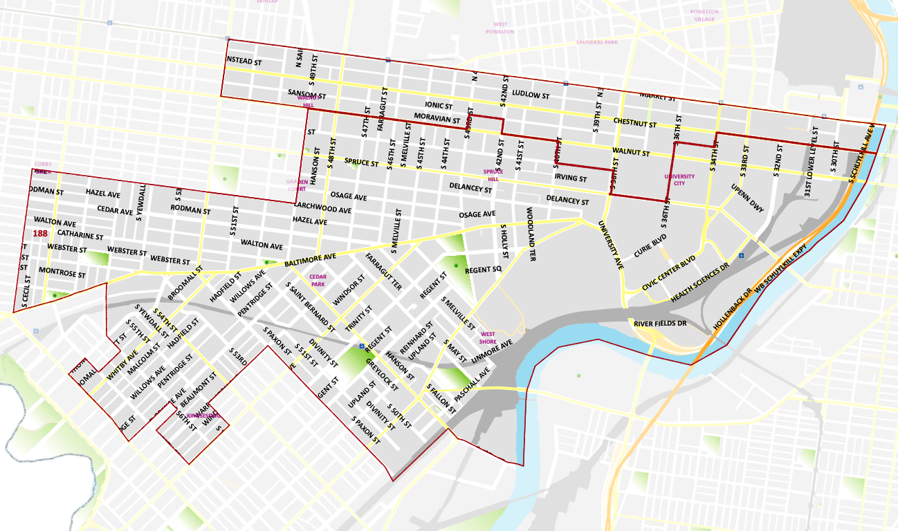
District 188 Map
Pennsylvania’s 188th District includes parts of Spruce Hill, Squirrel Hill, Walnut Hill, Spruce Hill, Garden Court, Beige Block and University City.
Wards and Divisions in District 188: Wards 27, 46, 51*(Divisions 02, 04-06, 13-20, 26, and 28), and 60*(Divisions 01-03 and 23.)
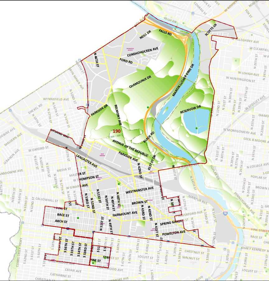
District 190 Map
Pensylvanias’s 190th District encompasses the communities of Belmont, Carroll Park, Cathedral Park, Mill Creek, Haddington, East Parkside, West Powelton, Allegheny West and Lehigh West.
Wards and Divisions in District 190: Wards 04* (Divisions 01, 07, 08, 12, 13, 19, and 20), 06, 24*(Divisions 06-08, 16, and 17), 38*(Division 09), 44, 52*(Divisions 01-04, 06-13, 21 and 28), and 60*(Divisions 04-06, 08-18, 20, and 21.)
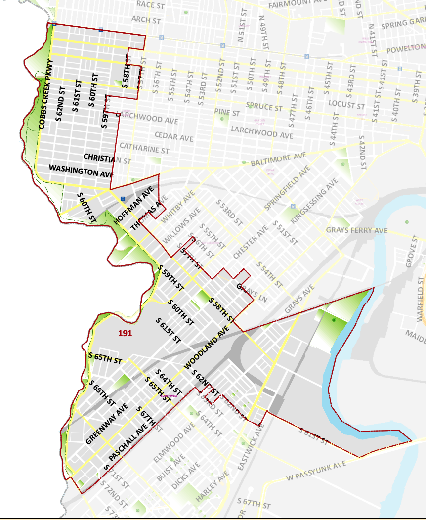
District 191 Map
Pennsylvania’s 191st District includes part of Delaware County consisting of the boroughs of Darby and Yeadon.
Wards and Divisions in District 191: Wards 03, 40* (Divisions 02-14, 19-21, 23-26, 33, 34, and 47), 51*(Divisions 01, 23, 25, and 27), and 60*(Divisions 07, 19, and 22) (This district also includes parts of Delaware County.)
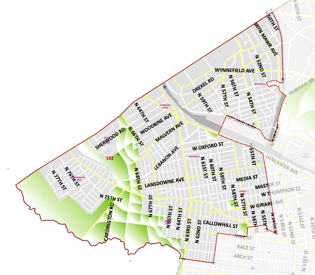
District 192 Map
Pennsylvania’s 192nd District includes part of Overbrook and Millbourne.
Wards and Divisions in District 192: Wards 04* (Divisions 02-06, 09-11, 14-18 and 21), 34, 52* (05, 14-20 and 22-27.)
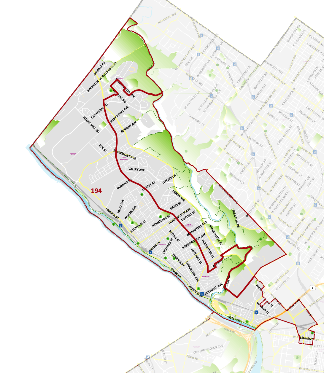
District 194 Map
Pennsylvania’s 194th District includes parts of Montgomery County consisting of the townships of Lower Merion, Part of Philadelphia County consisting of Manayunk, Roxborough and parts of North West Philadelphia and East Fields.
Wards and Divisions in District 194: Wards 21 and 38*(Divisions 01, 07, 08, 12-16, 19, and 20) (This district also includes parts of Montgomery County.)
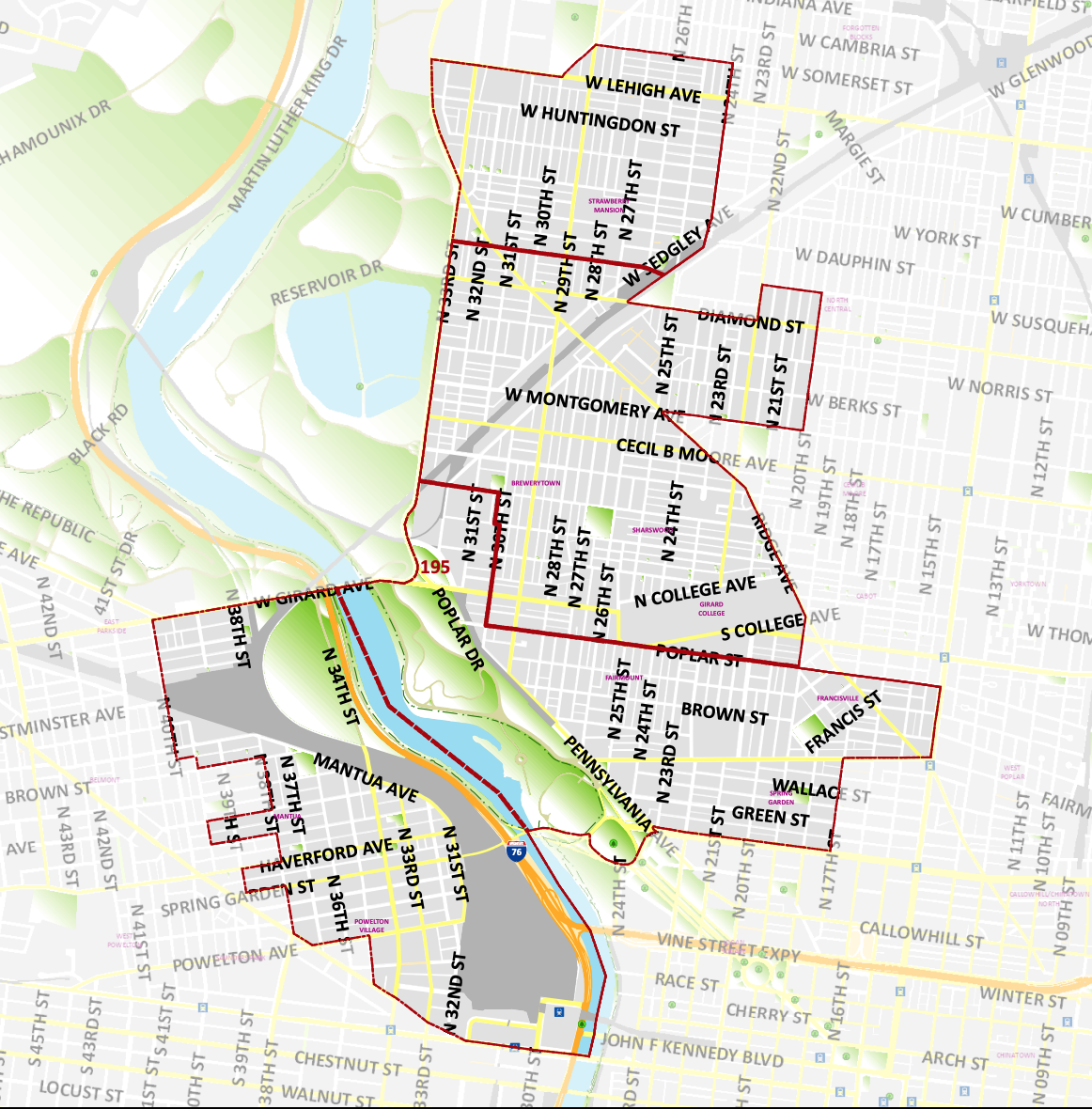
District 195 Map
Pennnsylvania’s 195th District includes parts of Strawberry Mansion, Brewerytown, Francisville, Spring Garden, Powelton Village, Sharswood and Mantua.
Wards and Divisions in District 195: Wards 15, 24*(Divisions 01-05, 09-15, 18, and 19), 28, 29 and 32*(Divisions 01-04, 10, 13-31.)
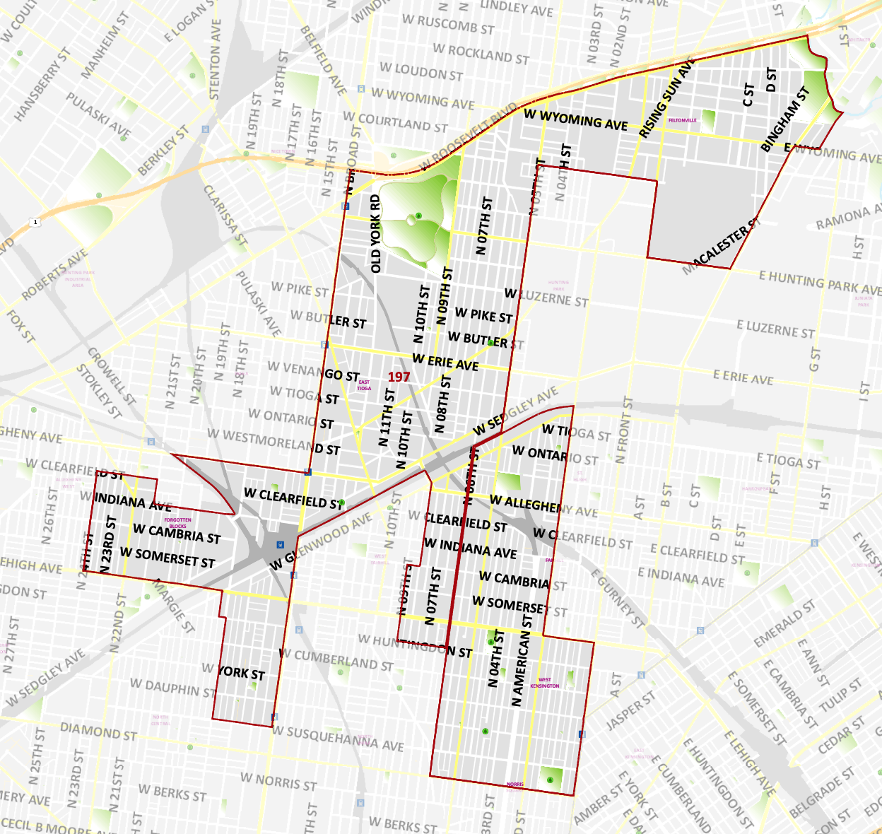
District 197 Map
Pennsylvania’s 197th District includes parts of Feltonville, Hunting Park, Glenwood, Fairhill, North Square and Francisville.
Wards and Divisions in District 197: Wards 11*(Divisions 01-03, 07, 08, 11, 13, 19, 20), 16*(Divisions 01-05), 19, 37*(Divisions 15, 16, and 18-20), 42*(Divisions 02-11, and 22), 43, and 49*(Division 01.)
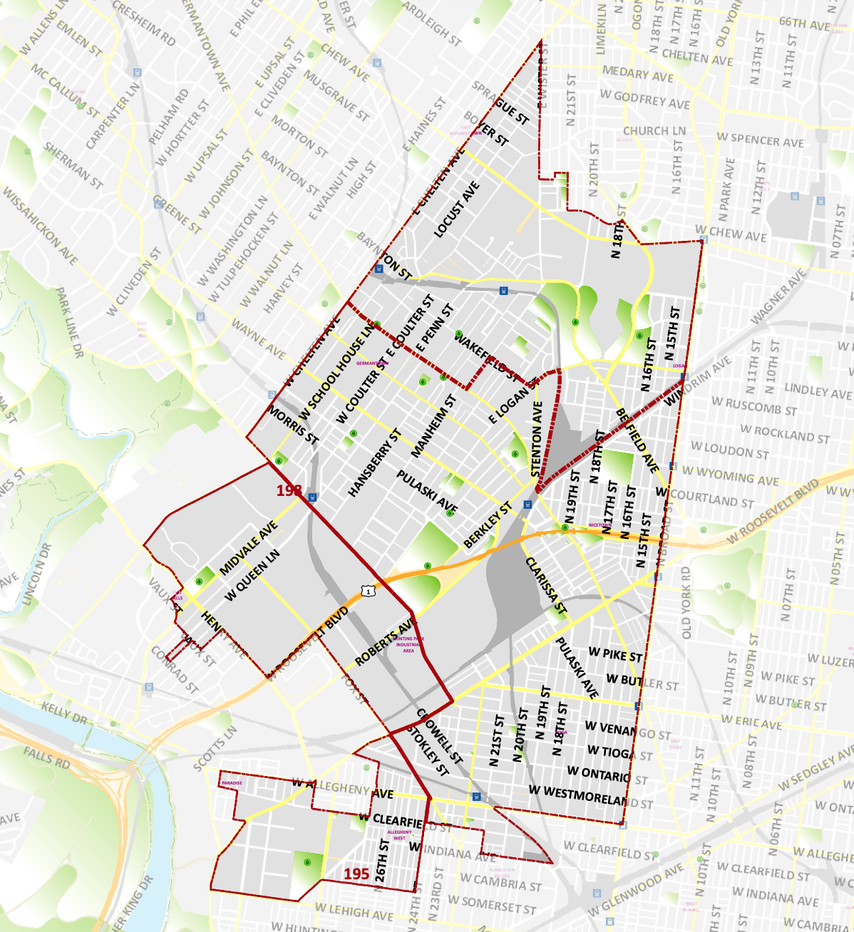
District 198 Map
Pennslvania’s 198th District includes parts of Germantown, East Falls and Upper North Philadelphia.
Wards and Divisions in District 198: Wards 11*(Divisions 04-06, 09, 10, 12, and 14-18), 12, 13, 17*(Divisions 16, 21-25, and 29), and 38*(Divisions 02-06, 10, 11, 17, 18, and 21.)
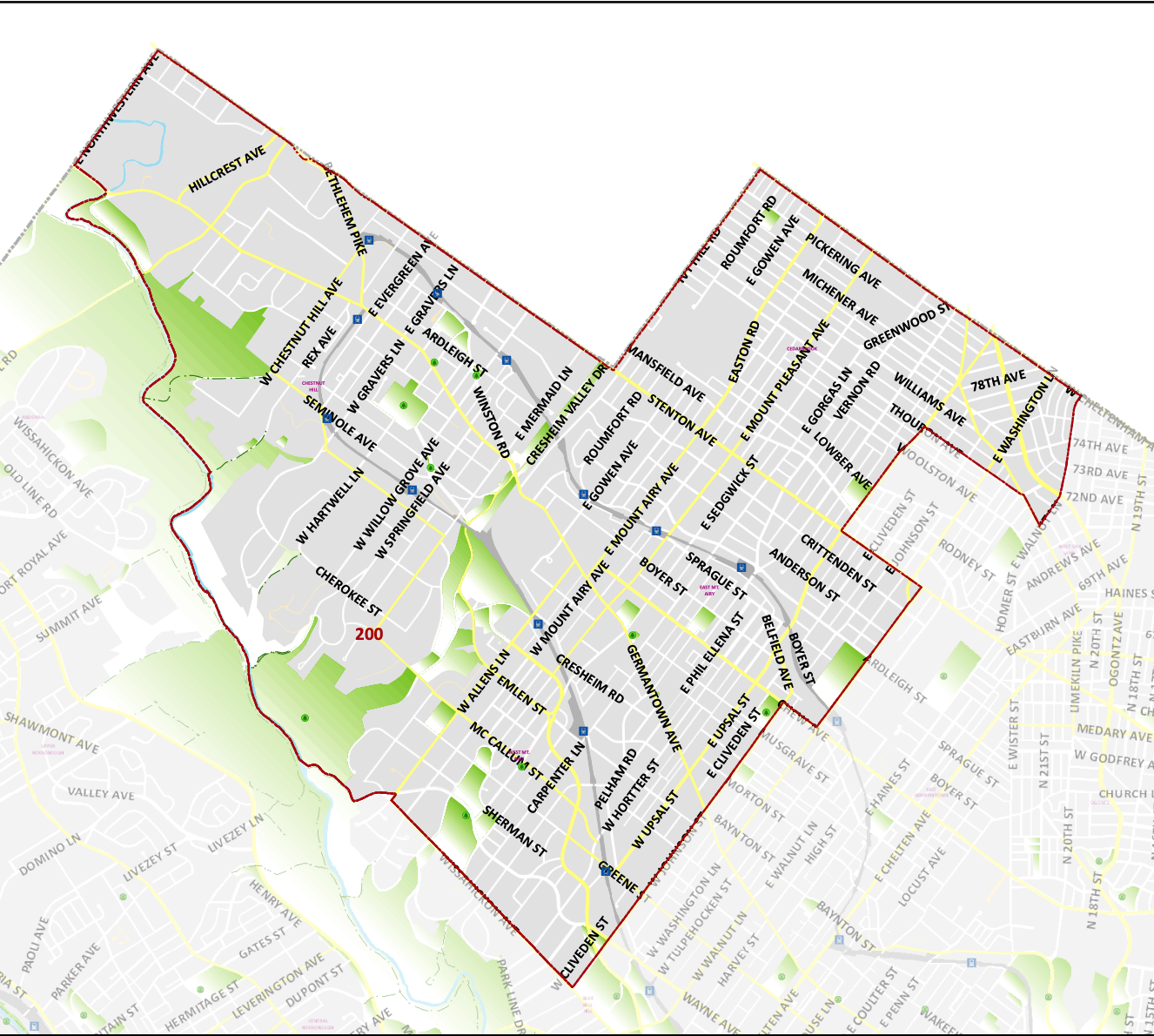
District 200 Map
Pennsylvania’s 200th District consists of Chestnut Hill, and parts of Northwest Philadelphia and West Mount Airy.
Wards in District 200: Wards 09, 22, and 50.
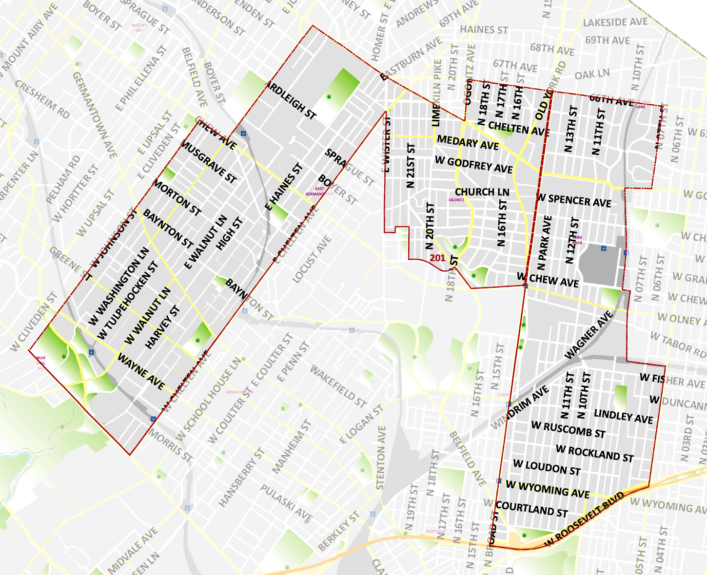
District 201 Map
Pennsylvania’s 201st District includes part of Germantown, Mt. Airy, West Oak Lane, and Ogontz neighborhoods.
Wards and Divisions in District 201: Wards 17*(Divisions 01-15, 17-20, 26-28), 49*(Divisions 02-22), and 59.
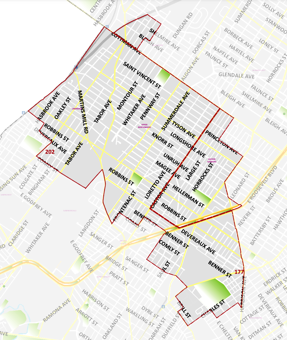
District 202 Map
Pennsylvnia’s 202nd District includes Lawncrest, and parts of Ashmead Village and Mayfair.
Wards and Divisions in District 202: Wards 35*(Divisions 01-08, 12, and 32), 53*(Divisions 02-23), 54*(Divisions 02-09, 11-13, and 16-18), 56*(Division 07), and 62*(Divisions 13, 15-18, and 20-26.)
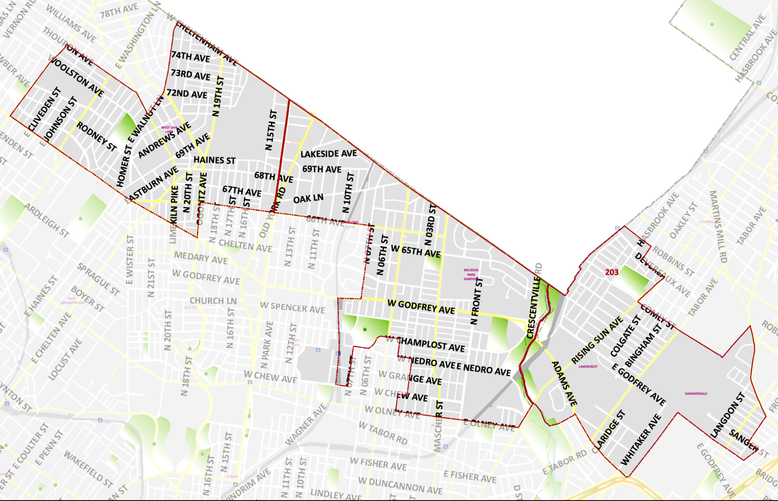
District 203 Map
Pennsylvania’s 203rd District includes West Oak Lane, East Oak Lane, Lawncrest and Lawn Dale.
Wards and Divisions in District 203: Wards 10, 35*(Divisions 09-11, 13, 14, 16-22, 25, 27, 28, and 31), and 61*(Divisions 04-06, 08-28.)
Not sure which state House district you live in? You can find your state representative by using Azavea's Elected Officials and Districts tool. This section includes the former state House district boundaries and those that went into effect in 2015.
Ward boundaries are not coterminous with state or federal political boundaries. An asterisk (*) indicates a ward in which only some divisions are included.
State House district maps provided by the Philadelphia City Planning Commission and ward and division information from County Board of Elections.

